File:Commons geocoding graph.svg

Original file (SVG file, nominally 600 × 500 pixels, file size: 23 KB)
Captions
Captions
 | This image requires updating Please see the talk page for more information.. In doing so, you could add a timestamp to the image.
|
Summary[edit]
| DescriptionCommons geocoding graph.svg |
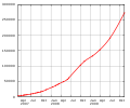
Čeština: Graf ukazující nárůst počet souborů, ke kterým byly doplněny souřadnice v souvislosti s projektem Geocoding
Deutsch: die Entwicklung der Anzahl georeferenzierter Bilder auf Commons
English: Graph of the amount of geocoded images on Commons |
| Date | and on (see file history in the bottom of this page) |
| Source | Own work |
| Author | Para |
| SVG development |
Licensing[edit]

|
Permission is granted to copy, distribute and/or modify this document under the terms of the GNU Free Documentation License, Version 1.2 or any later version published by the Free Software Foundation; with no Invariant Sections, no Front-Cover Texts, and no Back-Cover Texts. A copy of the license is included in the section entitled GNU Free Documentation License.http://www.gnu.org/copyleft/fdl.htmlGFDLGNU Free Documentation Licensetruetrue |
|
This file is licensed under the Creative Commons Attribution-Share Alike 3.0 Unported, 2.5 Generic, 2.0 Generic and 1.0 Generic license. | |
https://creativecommons.org/licenses/by-sa/3.0 CC BY-SA 3.0 Creative Commons Attribution-Share Alike 3.0 truetrue |
File history
Click on a date/time to view the file as it appeared at that time.
(newest | oldest) View (newer 10 | older 10) (10 | 20 | 50 | 100 | 250 | 500)| Date/Time | Thumbnail | Dimensions | User | Comment | |
|---|---|---|---|---|---|
| current | 16:01, 11 July 2010 |  | 600 × 500 (23 KB) | Para (talk | contribs) | 2010-07-11 live |
| 21:25, 8 February 2010 |  | 600 × 500 (27 KB) | Para (talk | contribs) | 2010-02-08 live | |
| 16:31, 15 November 2009 |  | 600 × 500 (26 KB) | Para (talk | contribs) | 2009-11-15 live | |
| 15:03, 3 July 2009 |  | 600 × 500 (27 KB) | Para (talk | contribs) | 2009-07-03 live | |
| 21:52, 30 March 2009 |  | 600 × 500 (24 KB) | Para (talk | contribs) | 20090330 live number | |
| 19:31, 21 January 2009 |  | 600 × 480 (26 KB) | Para (talk | contribs) | 2009-01-21 live | |
| 16:41, 1 October 2008 |  | 600 × 480 (26 KB) | Para (talk | contribs) | 2008-06-15 data & 2008-10-01 live number | |
| 15:32, 9 June 2008 |  | 600 × 480 (20 KB) | Para (talk | contribs) | 20080425 & 20080602 data | |
| 20:30, 18 March 2008 |  | 600 × 500 (21 KB) | Para (talk | contribs) | 20080214 & 20080303 & 20080316 data | |
| 19:06, 19 January 2008 |  | 600 × 480 (21 KB) | Para (talk | contribs) | 20080117 data |
You cannot overwrite this file.
File usage on Commons
The following 17 pages use this file:
- User:Sémhur/Brouillon
- User talk:Para/2008-08-08
- Commons:Coğrafi Kodlama
- Commons:Forum/Archiv/2007/September
- Commons:Forum/Archiv/2014/May
- Commons:GeoCommons
- Commons:Geocoding
- Commons:Geokodowanie
- Commons:Geokoodaus
- Commons:Geolocalización
- Commons:Georeferenziazione
- Commons:Georeferenzierung
- Commons:Giorifirinziazzioni
- Commons:ജിയോകോഡിങ്
- Commons:ジオコーディング
- Commons:地理编码工程
- Commons talk:Geocoding/Archive 3
File usage on other wikis
The following other wikis use this file:
- Usage on de.wikipedia.org
- Usage on es.wikipedia.org
Metadata
This file contains additional information such as Exif metadata which may have been added by the digital camera, scanner, or software program used to create or digitize it. If the file has been modified from its original state, some details such as the timestamp may not fully reflect those of the original file. The timestamp is only as accurate as the clock in the camera, and it may be completely wrong.
| Image title | Produced by GNUPLOT 4.2 patchlevel 2 |
|---|