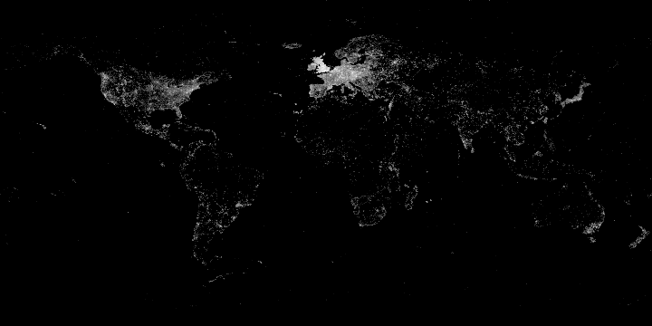
File:Geolocated images in Wikimedia Commons 2014-02-21.png
From Wikimedia Commons, the free media repository
Jump to navigation
Jump to search
Geolocated_images_in_Wikimedia_Commons_2014-02-21.png (720 × 360 pixels, file size: 24 KB, MIME type: image/png)
File information
Structured data
Captions
Add a one-line explanation of what this file represents
Captions
Summary[edit]
| DescriptionGeolocated images in Wikimedia Commons 2014-02-21.png |
English: Geolocated images in Wikimedia Commons. United Kingdom is overpopulated of geolocated images from the Geograph British Isles project. Español: Imágenes geolocalizadas en Wikimedia Commons. Reino Unido está superpoblado de imágenes provenientes de Geograph British Isles project. Français : Images géolocalisées sur Wikimedia Commons. |
| Date | |
| Source | Own work |
| Author | Zhuyifei1999 |
| Other versions |
|
| Generator |
|---|
# Quad-licensed under CC-BY-SA 3.0, GNU AGPL v3, MIT/Expat License, NCSA Open Source License
# Use and distribution are permitted as long as any one of the above licenses is satisfied.
from PIL import Image, ImageDraw

im = Image.new("L", (720, 360))
draw = ImageDraw.Draw(im)

query = """
SELECT 180-ROUND(gt_lat*2),
    ROUND(gt_lon*2)+360,
    ROUND(LOG2(COUNT(gt_page_id))*16)
FROM geo_tags
INNER JOIN page
    ON page_id = gt_page_id
WHERE gt_globe = "earth"
    AND NOT (
        gt_lat = 0
        AND gt_lon = 0
    )
    AND page_namespace = 6
GROUP BY ROUND(gt_lat*2),
    ROUND(gt_lon*2)
ORDER BY COUNT(gt_page_id) DESC
;"""

import MySQLdb

connection = MySQLdb.connect(
    host = "commonswiki.labsdb",
    db = "commonswiki_p",
    read_default_file = "~/replica.my.cnf"
)
cursor = connection.cursor()
cursor.execute(query)

for y, x, c in cursor.fetchall():
    draw.point((x,y), fill=c)

im.save("File:Geolocated_images_in_Wikimedia_Commons_2014-02-21.png", "PNG")
|
Licensing[edit]
I, the copyright holder of this work, hereby publish it under the following license:
|
This file is licensed under the Creative Commons Attribution-Share Alike 3.0 Unported license. | |
https://creativecommons.org/licenses/by-sa/3.0 CC BY-SA 3.0 Creative Commons Attribution-Share Alike 3.0 truetrue |
File history
Click on a date/time to view the file as it appeared at that time.
| Date/Time | Thumbnail | Dimensions | User | Comment | |
|---|---|---|---|---|---|
| current | 13:07, 21 February 2014 |  | 720 × 360 (24 KB) | Zhuyifei1999 (talk | contribs) | User created page with UploadWizard |
You cannot overwrite this file.
File usage on Commons
The following 11 pages use this file:
- Commons:Forum/Archiv/2014/May
- Commons:Geocoding
- Commons:Georeferenziazione
- Commons:Giorifirinziazzioni
- Commons:ジオコーディング
- File:Geolocated images in Wikimedia Commons 2012-01-21.png
- File:Geolocated images in Wikimedia Commons 2012-01-21 remake.png
- File:Geolocated images in Wikimedia Commons 2015-01-07.png
- File:Geolocated images in Wikimedia Commons 2016-04-16.png
- File:Geolocated images in Wikimedia Commons 2017-09-20.png
- File talk:Commons geocoding graph.svg
File usage on other wikis
The following other wikis use this file:
- Usage on bg.wikipedia.org
- Usage on de.wikipedia.org


